Enregistrez gratuitement cette image
en 800 pixels pour usage maquette
(click droit, Enregistrer l'image sous...)
|
|
Réf : T02091
Thème :
Terre vue de l'espace - Montagnes - Collines - Neige - Glace (539 images)
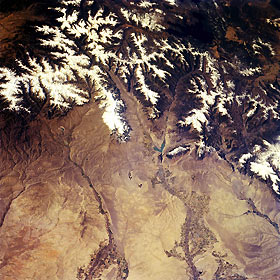
Titre : Bighorn Basin, Cody, and Yellowstone, Wyoming, U.S.A. October 1994
Description : (La description de cette image n'existe qu'en anglais)
The snow-covered peaks of the Absaroka Range and the western portion of the Bighorn Basin, a large, oval depression that is almost completely surrounded by mountain ranges, are visible in this west-looking, low-oblique photograph. The north and south forks of the Shoshone River converge at the Buffalo Bill Reservoir and flow northeastward through the city of Cody (barely discernible) and irrigated agricultural land to the Bighorn River near the Montana-Wyoming border. The Greybull River flows northeastward from the southern Absaroka Range (upper left) through irrigated agricultural land (bottom center) before joining the Bighorn River at the city of Greybull. Buffalo Bill Dam, completed in 1910 and the first concrete arch dam in the world, and its reservoir are used for hydroelectric power, downstream irrigation, and recreation. East of the dam on the Shoshone River lies Cody, founded and incorporated in 1901 by William F. Cody (Buffalo Bill). The city is a tourist resort at the eastern entrance to Yellowstone National Park. Dark blue Yellowstone Lake is the largest high altitude lake in North America at 7331 feet (2236 meters) and covers 139 square miles (360 square kilometers).
|
|

